Save as PDF
Washington State Recreation and Conservation Office
Project Snapshot
PRISM Project #04-1503 (Completed)
Entiat R. BridgeToBridge Reach Rest. Ph1
    Project Details    
Cascadia Conservation District; Entiat R. BridgeToBridge Reach Rest. Ph1 (#04-1503)

02/22/2008, Attachment #59528, P1010982
Cascadia Conservation District; Entiat R. BridgeToBridge Reach Rest. Ph1 (#04-1503) 02/22/2008, Attachment #59528, P1010982

Cascadia Conservation District; Entiat R. BridgeToBridge Reach Rest. Ph1 (#04-1503)

02/22/2008, Attachment #59528, P1010982 Cascadia Conservation District; Entiat R. BridgeToBridge Reach Rest. Ph1 (#04-1503)

Attachment #7985, Bridge-to-Bridge reach vicinity mapCascadia Conservation District; Entiat R. BridgeToBridge Reach Rest. Ph1 (#04-1503)

Attachment #7987, Bridge-to-Bridge reach actions/phases mapCascadia Conservation District; Entiat R. BridgeToBridge Reach Rest. Ph1 (#04-1503)

Attachment #7988, Bridge-to-Bridge reach ownership/parcel mapCascadia Conservation District; Entiat R. BridgeToBridge Reach Rest. Ph1 (#04-1503)

02/22/2008, Attachment #59563, P1010985Cascadia Conservation District; Entiat R. BridgeToBridge Reach Rest. Ph1 (#04-1503)

02/22/2008, Attachment #59564, Cross-vane at Canal InletCascadia Conservation District; Entiat R. BridgeToBridge Reach Rest. Ph1 (#04-1503)

02/22/2008, Attachment #59565, Cross-vane and Canal InletCascadia Conservation District; Entiat R. BridgeToBridge Reach Rest. Ph1 (#04-1503)

05/01/2008, Attachment #59574, SRFB Tour near Fire StationCascadia Conservation District; Entiat R. BridgeToBridge Reach Rest. Ph1 (#04-1503)

05/01/2008, Attachment #59575, Steelhead Redd in PUD CanalCascadia Conservation District; Entiat R. BridgeToBridge Reach Rest. Ph1 (#04-1503)

05/01/2008, Attachment #59576, Orofice at PUD Canal InletCascadia Conservation District; Entiat R. BridgeToBridge Reach Rest. Ph1 (#04-1503)

05/01/2008, Attachment #59577, New RCO Staff Learning about ReddsCascadia Conservation District; Entiat R. BridgeToBridge Reach Rest. Ph1 (#04-1503)

05/01/2008, Attachment #59578, Debris Catcher at PUD Canal Entrance + ReddCascadia Conservation District; Entiat R. BridgeToBridge Reach Rest. Ph1 (#04-1503)

05/01/2008, Attachment #59579, Rich Malinowski holding Court at PUD Canal InletCascadia Conservation District; Entiat R. BridgeToBridge Reach Rest. Ph1 (#04-1503)

05/01/2008, Attachment #59597, SRFB Tour Ortho Map 05-01-08Cascadia Conservation District; Entiat R. BridgeToBridge Reach Rest. Ph1 (#04-1503)

09/30/2007, Attachment #59600, 04 1503-b2b before after
Project Status:  Closed Completed since 05/30/2008
 
Project Type:  Restoration
Project Sponsor:  Cascadia Conservation District
Funding Board:  Salmon Recovery Funding Board
              Funding  
Salmon Federal Projects: $102,555
Total RCO Grant: $102,555 (83%)
Sponsor Match: $20,451 (17%)
Total Agreement: $123,006 (100%)
              Links
 

    Project Description    
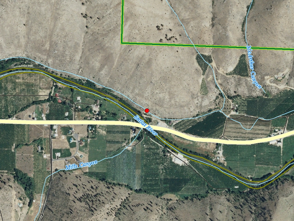
The CCCD, on behalf of the Entiat WRIA Planning Unit (EWPU), will implement Phase I of a full ~1.2 RM reach restoration in the lower mainstem Entiat River. The "Bridge-to-Bridge" (B-to-B) reach (~RM 3.2 to RM 4.4) is the highest priority restoration area in WRIA 46. Past activities that have altered the lower Entiat River include logging, dams, stream clearing; channelization, filling & flood control protection works. Riparian vegetation has been removed by fire & development. The B-to-B effort addresses lack of off-channel rearing habitat, temperature extremes & habitat simplicity. It will restore geomorphology, floodplain function, habitat complexity/diversity, off-channel habitat, and shading, benefiting adult & juvenile Chinook, steelhead & coho. At the end of Phase 3, the reach will be restored to its geomorphic potential (e.g. now 0.3 pools/mi, restored to 9 pools/mi). The EWPU supports this 3-phase project, developed via 10 years of planning. Actions proposed are based on geomorphic, biologic, hydrologic & thermal analyses. Funding for Phase 1 will be used to: (a) restore ~1000 contiguous ft. of riparian vegetation to improve stream temperatures, bank condition, cover, nutrient inputs; (b) provide juvenile off-channel rearing habitat via rock/LWD placement in ~700 ft. irrigation ditch; (c) install 2 instream structures to direct flow to the off-channel habitat and restore resting pools in the lowest portion of the reach. A ditch outfall structure will also be added.


    Project Contacts    
         
Project Sponsor: Cascadia Conservation District Lead Entity: Upper Columbia Salmon Recovery Board Lead Entity
  Project Contact: Mike Rickel

(509) 436-1601
   
 
Funding Agency: Recreation and Conservation Office    
  Project Manager: Amee Bahr
Amee.Bahr@rco.wa.gov
(360) 867-8585
   

    Project Location    
General Area:   RM 3.2-4.4 of the Entiat River
Waterbody:   Columbia River, Entiat River, Phase I - Lower Bridge area
County:   Chelan
Legislative District:   12
Congressional District 2022:   08
Salmon Recovery Regions:   Upper Columbia River
Watershed Administrative Unit:   Lower Entiat
HUC8:   Upper Columbia-Entiat (17020010)
WRIA:   Entiat
Sections:   13
Township:   T25NR20E
Coordinates:   47.66819355
-120.28118495

    Worksites    
Worksite NameScope of WorkActual Restoration Cost
Entiat R. Bridge to Bridge Rest. (#1) Architectural & Engineering (A&E), Channel reconfiguration and connectivity (C.4.c.1), Channel structure placement (C.4.d.1), Obtain permits, Other restoration activities, Planting (C.5.c.1), Streambank stabilization (C.4.e.1) $146,354
 Total$146,354
Amounts may not be complete

    Properties    
Worksite Name Property NameLandowner Type
Entiat R. Bridge to Bridge Rest. (#1)   Property 1 - Property - Worksite #1 Private
   Total
Amounts may not be complete

    Project Metrics (Outcomes, Benefits)    
 Category / Work Type / MetricFinal

Restoration Metrics (rolled up from Worksite level)

Instream Habitat Project
      Channel reconfiguration and connectivity (C.4.c.1)
Miles of Stream Treated for channel reconfiguration and connectivity (C.4.c.3) 0.32
Miles of Off-Channel Stream Created or Connected (C.4.c.4) 0.13
Acres Of Channel/Off-Channel Connected Or Added (C.4.c.5) 0.2
Instream Pools Created/Added (C.4.c.6) 4
      Channel structure placement (C.4.d.1)
Miles of Stream Treated for channel structure placement (C.4.d.3) 0.15
Pools Created through channel structure placement (C.4.d.5) 4
Number of structures placed in channel (C.4.d.7) 2

Riparian Habitat Project
      Planting (C.5.c.1)
Acres Planted in riparian (C.5.c.3) 0.6

Permits
      Obtain permits
Number of permits required for implementation of project 5

    Project Milestones    
Milestone NameTarget DateDescription
Project Start 01/03/2005
Construction Started 08/01/2006 May be as early as Aug 2005
Construction Complete 10/31/2006 May be as early as Oct 2005
Agreement End Date 06/30/2008 Allows for replanting if needed
Final Docs/Billing to Mgmt Agy 08/15/2008


    Project Attachments    
Attachment TypeAttachment TitleAttach Date
Application authorization CCCD Authorization Memorandum for Bridge-To-Bridge project.jpg 05/25/2004
Certification of Applicant Match USFS root wads - Federal donated materials.jpg 05/25/2004
Certification of Applicant Match State Coastal Protection Fund Match - 15%.jpg 05/25/2004
Correspondence B2B_References.pdf 05/26/2004
Design document (as built) Final Report & As-Built Designs 04-28-08.pdf 05/28/2008
Evaluation proposal Evaluation Proposal.pdf 07/16/2004
Final project report RCO Final Report 4-23-08.pdf 05/28/2008
Landowner acknowledgement form Wright LWF.pdf 09/14/2004
Landowner acknowledgement form Robert Scoville landowner willingness form.jpg 05/25/2004
Landowner acknowledgement form Robert Whitehall landowner willingness form.jpg 05/25/2004
Landowner acknowledgement form WDFW landowner willingness form.jpg 05/25/2004
Landowner acknowledgement form Bill Small landowner willingness form.jpg 05/25/2004
Landowner acknowledgement form Conard Petersen landowner willingness form.jpg 05/25/2004
Landowner acknowledgement form Ronald Mullek landowner willingness form.jpg 05/25/2004
Landowner acknowledgement form Misty McHargue landowner willingness form.jpg 05/25/2004
Map Bridge-to-Bridge reach ownership/parcel map.jpg 05/25/2004
Map Bridge-to-Bridge reach actions/phases map.jpg 05/25/2004
Map Bridge-to-Bridge reach vicinity map.jpg 05/25/2004
Photo 04 1503-b2b before after.jpg 05/29/2008
Photo SRFB Tour Ortho Map 05-01-08.jpg 05/29/2008
Photo Rich Malinowski holding Court at PUD Canal Inlet.jpg 05/29/2008
Photo Debris Catcher at PUD Canal Entrance + Redd.jpg 05/29/2008
Photo New RCO Staff Learning about Redds.jpg 05/29/2008
Photo Orofice at PUD Canal Inlet.jpg 05/29/2008
Photo Steelhead Redd in PUD Canal.jpg 05/29/2008
Photo SRFB Tour near Fire Station.jpg 05/29/2008
Photo Cross-vane and Canal Inlet.jpg 05/29/2008
Photo Cross-vane at Canal Inlet.jpg 05/29/2008
Photo P1010985.jpg 05/29/2008
Photo P1010982.jpg 05/28/2008

Back to top Date of last change: 08/11/2023