Entiat National Fish Hatchery Floodplain Connectio

03/30/2012, Attachment #148774, Levee Removal Restoration")
|
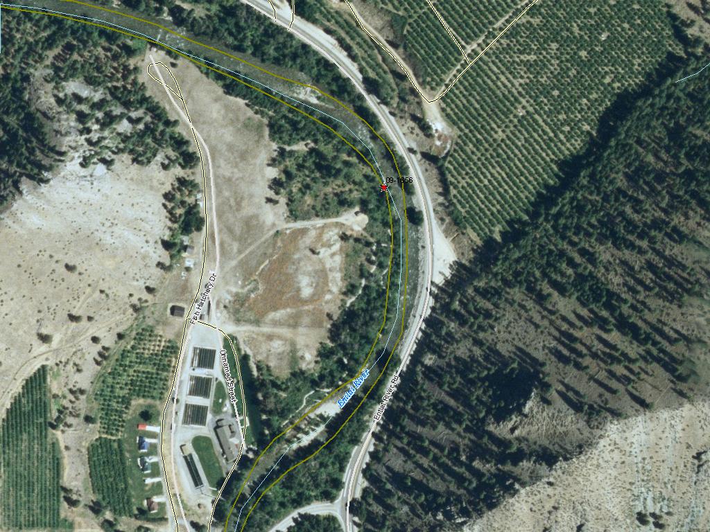
Cascadia Conservation District; Entiat National Fish Hatchery Floodplain Connectio (#09-1656)
03/30/2012, Attachment #148774, Levee Removal Restoration
|
|
|
|
|
|
This project is located on the mainstem Entiat River at approximately RM 6.8 to 7.1. Following European settlement, human activities have greatly altered the lower Entiat River, though only qualitative or anecdotal information exists with which to compare present-day conditions. Localized channelization, removal of riparian vegetation, floodplain development, and dam building have perhaps been the most impactful anthropogenic activities in this reach. This project affords a rare opportunity to address these issues over a significant length of river by attempting to return those missing elements of river function. A levee on the upstream portion of the property has disconnected the river from its right-bank floodplain, while large wood and natural, off-channel habitat are all but missing from the lower river. This project aims to reactivate the Entiat National Fish Hatchery (ENFH) floodplain (or at least promote a trajectory for improvement in the future) by removing much of this levee. Future project phases will increase the amount of off-channel habitat and construct multiple LWD jams to further reactivate the ENFH floodplain. It is important to demonstrate the need and benefits of reach-scale, ecological process-driven restoration to Entiat landowners who have generally not embraced levee removal or LWD as a desirable technique for salmon recovery. In doing so, we hope to show the compatibility of floodplain infrastructure with floodplain restoration.
|
|
General Area:
|
|
Appx. 6 miles west of Entiat, WA.
|
|
Waterbody:
|
|
Columbia River, Entiat River
|
|
County:
|
|
Chelan
|
|
Legislative District:
|
|
12
|
|
Congressional District 2022:
|
|
08
|
|
Salmon Recovery Regions:
|
|
Upper Columbia River
|
|
Watershed Administrative Unit:
|
|
Lower Entiat
|
|
HUC8:
|
|
Upper Columbia-Entiat (17020010)
|
|
WRIA:
|
|
Entiat
|
|
Sections:
|
|
03
|
|
Township:
|
|
T25NR20E
|
|
Coordinates:
|
|
47.70062580
-120.32042111
|
|
|
| Worksite Name | Scope of Work | Actual Restoration Cost |
|
Entiat National Fish Hatchery floodplain (#1)
|
Architectural & Engineering (A&E), Channel reconfiguration and connectivity (C.4.c.1), Cultural resources, Obtain permits, Other restoration activities, Planting (C.5.c.1), Streambank stabilization (C.4.e.1)
|
$107,767
|
| | Total | $107,767 |
Amounts may not be complete
| Worksite Name | | Property Name | Landowner Type |
|
Entiat National Fish Hatchery floodplain (#1)
|
|
Property 1 - Entiat National Fish Hatchery
|
Federal Government
|
| | | | Total |
Amounts may not be complete
| | Category / Work Type / Metric | Final |
Restoration Metrics (rolled up from Worksite level) |
Instream Habitat Project |
| Channel reconfiguration and connectivity (C.4.c.1) |
|
|
Miles of Stream Treated for channel reconfiguration and connectivity (C.4.c.3)
|
0.20
|
Riparian Habitat Project |
| Planting (C.5.c.1) |
|
|
Acres Planted in riparian (C.5.c.3)
|
3.7
|
Permits |
| Obtain permits |
|
|
Number of permits required for implementation of project
|
2
|
| Milestone Name | Target Date | Description |
|
Project Start
|
12/10/2009
|
|
|
Applied for Permits
|
01/31/2010
|
|
|
Cultural Resources Complete
|
04/30/2010
|
USFWS will complete - project takes place on Federal Property
|
|
Progress Report Due
|
06/30/2010
|
|
|
Annual Project Billing Due
|
07/31/2010
|
|
|
Progress Report Due
|
12/01/2010
|
|
|
Progress Report Due
|
06/30/2011
|
|
|
Annual Project Billing Due
|
07/31/2011
|
|
|
Progress Report Due
|
12/01/2011
|
|
|
Progress Report Due
|
06/30/2012
|
|
|
Annual Project Billing Due
|
07/31/2012
|
|
|
Agreement End Date
|
09/30/2012
|
|
|
Final Billing Due
|
12/31/2012
|
|
|
Final Report Due
|
12/31/2012
|
|
|
Landowner Agreement to RCO
|
12/31/2012
|
|