DeMolay Sandspit Bulkhead Removal Design
Pierce Conservation District (PCD) will complete a feasibility study, conceptual design alternatives, and preliminary (permit-ready) design for shoreline armor removal at the Tacoma DeMolay Sandspit Nature Preserve. The Preserve, located at the northern tip of Fox Island in Pierce County, is a Peninsula Metropolitan Park District property with over 2,000 ft of public shoreline, approximately 600 ft of which is armored with concrete bulkhead and debris. Important habitat features on site include eelgrass beds, barrier embayment, and documented surf smelt spawning habitat along the entirety of the Preserve (WDFW 2013).
This bulkhead removal is identified as a priority nearshore project by the West Sound Lead Entity to support priority species including juvenile Puget Sound Chinook and forage fish. Shoreline armor removal will restore degraded sediment processes, reconnect mature shoreline vegetation, improve public access, support critical habitat for priority species, and act as a demonstration site for the Shore Friendly program. As a demonstration site, the project will offer Pierce County residents a local example of multi-benefit nearshore restoration.
|
|
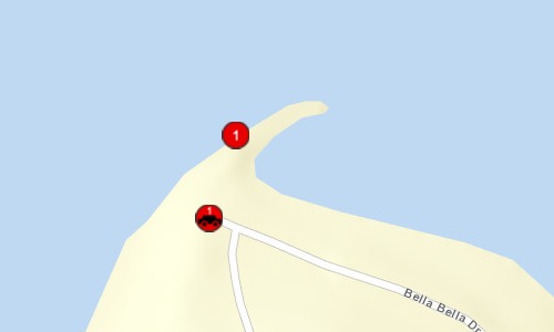
General Area:
|
|
Fox Island in Pierce County
|
|
County:
|
|
Pierce
|
|
Legislative District:
|
|
26
|
|
Congressional District 2022:
|
|
06
|
|
Salmon Recovery Regions:
|
|
Puget Sound
|
|
Watershed Administrative Unit:
|
|
Clovos Passage/Carr Inlet
|
|
HUC8:
|
|
Puget Sound (17110019)
|
|
WRIA:
|
|
Kitsap
|
|
Coordinates:
|
|
47.27793393
-122.66616338
|
|
|
Amounts may not be complete
| Worksite Name | | Property Name | Landowner Type |
|
DeMolay Sandspit Nature Preserve (#1)
|
|
Property 1 - Tacoma DeMolay Sandspit Nature Preserve
|
Local Government
|
| | | | Total |
Amounts may not be complete
| | Category / Work Type / Metric | Final |
Restoration Metrics (rolled up from Worksite level) |
|
| |
|
|
Area Encompassed (acres) (B.0.b.1)
|
5.1
|
|
|
Miles of Stream and/or Shoreline Affected (B.0.b.2)
|
0.11
|
| Milestone Name | Target Date | Description |
|
RFP Complete/Consultant Hired
|
02/24/2021
|
|
|
Project Start
|
07/01/2021
|
|
|
Cultural Resources Complete
|
09/30/2021
|
RCO to verify cultural resources requirements
|
|
Progress Report Due
|
10/15/2021
|
|
|
Other
|
10/31/2021
|
Tabletop Habitat assessment, Geotechnical and hydrogeology assessment, and coastal design critaria evaluation (to be included in Feasibility Report)
|
|
Cultural Resources Complete
|
10/31/2021
|
Cultural survey complete
|
|
Other
|
12/31/2021
|
Compile existing conditions data and identify site constraints and opportunities map
|
|
Other
|
12/31/2021
|
Community meeting and stakeholder engagement minutes
|
|
Other
|
12/31/2021
|
Final feasibility study report
|
|
Progress Report Due
|
04/15/2022
|
|
|
Progress Report Due
|
10/15/2022
|
|
|
Annual Project Billing Due
|
11/01/2022
|
|
|
Cultural Resources Complete
|
04/17/2023
|
Archaeological monitoring report of geotechnical investigation, if required
|
|
Progress Report Due
|
04/18/2023
|
|
|
Draft Design to RCO
|
06/01/2023
|
Draft Preliminary Design Report and Drawings
|
|
Preliminary Design to RCO
|
06/30/2023
|
Prelim design and outline of technical specifications
|
|
Special Conditions Met
|
06/30/2023
|
Ensure compliance with attached statement of work
|
|
Permits Complete
|
06/30/2023
|
Permit Application Package
|
|
Agreement End Date
|
06/30/2023
|
|
|
Final Report Due
|
08/16/2023
|
|
|
Final Billing Due
|
08/31/2023
|
|
| Attachment Type | Attachment Title | Attach Date |
|
Agreement - State
|
20-1510 Agreement - DeMolay Sandspit Bulkhead Removal Design.pdf
|
09/13/2021
|
|
Applicant Resolution/Authorizations
|
Updated authorization authority Sept 2021.pdf
|
09/21/2021
|
|
Applicant Resolution/Authorizations
|
Signed_ApplicantAuthorization_DeMolay.pdf.pdf
|
07/16/2020
|
|
Application Review Report
|
Grant Manager Comments, 20-1510P(compl 10/30/20 09:31).pdf
|
10/30/2020
|
|
Application Review Report
|
Grant Manager Comments Report, 20-1510P(rtnd 07/26/20 13:16:.pdf
|
07/26/2020
|
|
Budget Worksheet
|
20-1510_P_DeMolay_ESRP Restoration & Protection Grant_Budget.xlsx
|
07/22/2020
|
|
Cost Estimate
|
Pre-Proposal Draft Cost Estimate.pdf
|
04/13/2020
|
|
Cultural Resource Screening Report
|
Project Cultural Resource Screening Report (06/15/21 17:08:0.pdf
|
06/15/2021
|
|
Design document
|
DeMolay_FeasibilityReport_Final_20211209.pdf.pdf
|
09/27/2022
|
|
Design document
|
07192021_Concepts_Demolay.pdf
|
01/07/2022
|
|
Design document
|
Feasibility Study Appendix C_Habitat_Figures.pdf.pdf
|
11/02/2021
|
|
Final project report
|
Final Report, 20-1510 (accepted 08/28/23 16:24:46).pdf
|
08/28/2023
|
|
Letters of Support
|
20-1510 _Pen Met Parks Ltr of Support.pdf.pdf
|
07/23/2020
|
|
Letters of Support
|
20-1510 West Sound Partners Ltr of Support.pdf
|
07/22/2020
|
|
Letters of Support
|
20-1510 Harbor Wild Watch Ltr of Support.pdf
|
07/21/2020
|
|
Letters of Support
|
20-1510 KGI Watershed Council Ltr of Support.pdf
|
07/21/2020
|
|
Map: Area of Potential Effect (APE)
|
Project APE Report (06/15/21 17:08:04).pdf
|
06/15/2021
|
|
Map: Area of Potential Effect (APE)
|
Area of Potential Effect_20-1510_P DeMolay Sandspit Nature P.pdf
|
07/22/2020
|
|
Map: Planning Area
|
DeMolay Sandspit Nature Preserve_Planning Area.pdf.pdf
|
04/10/2020
|
|
Map: Site Location
|
DeMolay_Vicinity Map.pdf.pdf
|
04/10/2020
|
|
Photo
|
Site Photo 2_20-1510 DeMolay Sandspit Nature Preserve Bulkhe.jpeg
|
07/21/2020
|
|
Photo
|
Site Photo 3_20-1510 DeMolay Sandspit Nature Preserve Bulkhe.jpg
|
07/21/2020
|
|
Photo
|
Site Photo 1_20-1510 DeMolay Sandspit Nature Preserve Buklhe.jpeg
|
07/21/2020
|
|
Progress report
|
Progress Report, 20-1510 (accepted 04/25/23 17:41:50).pdf
|
04/25/2023
|
|
Progress report
|
Progress Report, 20-1510 (accepted 02/13/23 19:19:39).pdf
|
02/13/2023
|
|
Progress report
|
Progress Report, 20-1510 (accepted 10/06/22 22:57:09).pdf
|
10/06/2022
|
|
Progress report
|
Progress Report, 20-1510 (accepted 09/25/21 16:19:39).pdf
|
09/25/2021
|
|
Project Application Report
|
Project Application Report, 20-1510P (sub 06/15/21 17:08:33).pdf
|
06/15/2021
|
|
Project Application Report
|
Project Application Report, 20-1510P (sub 06/15/21 16:03:59).pdf
|
06/15/2021
|
|
Project Application Report
|
Project Application Report, 20-1510P (sub 06/14/21 10:10:50).pdf
|
06/14/2021
|
|
Project Application Report
|
Project Application Report, 20-1510P (sub 09/23/20 09:45:20).pdf
|
09/23/2020
|
|
Project Application Report
|
Project Application Report, 20-1510P (sub 07/23/20 08:22:34).pdf
|
07/23/2020
|
|
Project Deliverables
|
JARPA Appendices A-D.pdf.pdf
|
08/22/2023
|
|
Project Deliverables
|
Permit Application Materials.doc
|
08/22/2023
|
|
Project Deliverables
|
Demolay_ JARPA Figures.pdf.pdf
|
08/22/2023
|
|
Project Deliverables
|
Demolay_PreDesignReport_Apps.pdf.pdf
|
08/22/2023
|
|
Project Review Comments
|
Proj Review Comments Eval, 20-1510P(compl 06/14/21 10:09).pdf
|
06/14/2021
|
|
Scope of work
|
20-1510 Statement of Work 08142021.docx
|
08/14/2021
|
|
Visual Scope of Work
|
Visual Scope of Work_20-1510_P DeMolay Sandspit Nature Prese.pdf
|
07/22/2020
|
|
Visuals
|
TECHNICAL PRESENTATION_20-1510 P_DeMolay Sandspit Nature Pre.pdf
|
08/24/2020
|